GPS equipment has revolutionized land surveying, allowing surveyors to determine precise coordinates and create accurate maps quickly and reliably. This advancement has transformed how surveyors approach their work, enabling them to tackle more complex projects confidently.
What is GPS in land surveying?
GPS, or Global Positioning System, is a satellite-based technology that provides location and time information anywhere on Earth with an unobstructed line of sight to four or more GPS satellites.
Unlike traditional methods that measure angles and distances between points, GPS enables surveyors to pinpoint precise locations regardless of weather or other conditions, increasing efficiency and accuracy. GPS technology revolutionizes how land surveyors determine the coordinates of survey points, calculate distances, and create accurate maps.
Key pieces of
GPS survey equipment include:
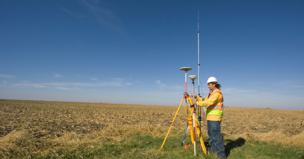
- Receivers: These devices receive signals from multiple GPS satellites and use them to calculate the exact position of a point on the Earth's surface.
- Rover rods and pole extensions: These extend the reach of the GPS equipment, allowing surveyors to measure points that are difficult to access directly.
- Vehicle mounts, bipods, and tripods: These provide stability by securely mounting the equipment.
- Antennae: Antennae increase the signal reception so that the system can receive satellite signals reliably.
For more about GPS,
read How to Use GPS for Land Surveying.
Types of GPS Land Surveying Equipment

By understanding the different types of GPS equipment available, surveyors can select the most appropriate tools based on their specific needs and project requirements to provide optimal performance and accuracy in their surveying tasks.
Handheld GPS Units
Handheld GPS units are portable devices designed for fieldwork. These small, battery-powered units typically feature a user-friendly interface, allowing surveyors to record coordinates easily and navigate to specific points.
Key Features:
- Portable and convenient for quick, on-the-go measurements.
- Generally more affordable compared to more advanced GPS equipment, making them accessible to a wider range of users.
- Suitable for both professional and amateur use, with intuitive controls and easy-to-read displays.
- Designed to withstand harsh environmental conditions, including water, dust, and impact resistance.
- Typically designed for extended use in the field, with long battery life and the ability to use replaceable or rechargeable batteries.
- May support multiple satellite constellations for improved accuracy and reliability.
For a deeper look at handheld GPS units,
refer to Handheld GPS Units vs. Total Stations.
Survey Grade GPS Receivers
Survey-grade GPS receivers are high-precision instruments used for professional land surveying. These devices provide highly accurate location data, essential for tasks that require exact measurements.
Key Features:
- Offers extremely precise location data, often achieving accuracy within a few millimeters.
- Equipped with high-quality antennas for improved signal reception.
- Built to withstand challenging field conditions, including harsh weather, dust, and impacts.
- Capable of receiving signals from multiple satellite constellations to improve positioning accuracy and reliability.
- Often compatible with RTK systems for real-time corrections and even higher accuracy.
- Equipped with substantial memory to store large amounts of survey data and support various data formats.
Differential GPS (DGPS) System
The
DGPS system improves the accuracy of standard GPS by using a fixed ground-based reference station to send correction signals to the GPS receiver. This system is essential for tasks requiring higher precision than what standalone GPS can provide.
Key Features:
- Significantly reduces the positional errors inherent in standalone GPS, often achieving sub-meter to centimeter-level accuracy.
- Improves the reliability of collected data, ensuring greater consistency and precision in measurements.
- It receives both the standard GPS signals and the correction signals from the reference station and applies the corrections in real-time to improve accuracy.
- The system includes a communication link to transmit correction signals from the reference station to the mobile receiver.
- DGPS can work with various GPS receivers, including handheld, survey grade, and even some GNSS receivers.
- It is suitable for various applications, including land surveying, marine navigation, agriculture, and geospatial data collection.
Read What Is the Difference Between GPS and DGPS for more information.
GNSS Receivers
Global Navigation Satellite System (GNSS) receivers are often used for international projects requiring cross-system compatibility and are ideal for high-precision tasks in varied geographic locations. GNSS receivers can access multiple satellite systems, including GPS, GLONASS, Galileo, and BeiDou, offering broader coverage and improved accuracy.
Key Features:
- Access to multiple satellite constellations reduces signal obstruction and improves performance in challenging environments such as urban areas and dense forests.
- By utilizing signals from multiple systems, GNSS receivers achieve higher accuracy and reliability compared to single-system GPS receivers.
- Ability to operate in varied geographic locations, making them suitable for international projects and areas with limited GPS coverage.
- Capable of receiving and processing signals on multiple frequencies, which helps mitigate errors caused by atmospheric conditions and multipath effects.
- Built to withstand harsh field conditions, including extreme temperatures, moisture, and physical impacts.
- Equipped with powerful processors and software integration for real-time data analysis, corrections, and mapping.
For additional information on GNSS, read
Guide to Real-Time Kinetic Surveying.
Real-Time Kinematic (RTK) GPS System
RTK GPS systems are an advanced form of GPS technology that enhances positioning accuracy by using carrier-phase measurements of the GPS signals. It involves a base station and a rover unit, where the base station sends correction data to the rover, significantly improving the accuracy of the position data.
Key Features:
- Achieves precise positioning, often within a few centimeters, making it suitable for high-precision tasks.
- Provides real-time correction data, which is invaluable for time-sensitive surveying tasks and applications requiring immediate results.
- Reduces the need for post-processing, saving time and improving workflow efficiency.
- Capable of using multiple frequencies, which helps to minimize errors caused by atmospheric disturbances and multipath effects.
- Guarantees reliable transmission of correction data from the base station to the rover, often using radio, cellular, or internet communication methods.
- Designed to withstand challenging field conditions, including extreme weather, rough terrain, and physical impacts.
For more information, refer to the
Guide to Real-Time Kinetic Surveying.
What to Consider When Choosing GPS Equipment
Selecting the right GPS equipment for surveying tasks involves evaluating several features to secure optimal performance and reliability in the field.
Accuracy and Precision
Different types of GPS equipment offer varying degrees of precision. Choosing equipment based on your accuracy and precision needs ensures that you get reliable results tailored to your specific project requirements.
Factors Affecting Accuracy and Precision:
- Satellite geometry: The positioning and number of satellites in view can impact accuracy. More satellites and better geometry (spread) generally lead to higher accuracy.
- Signal obstruction: Buildings, trees, and other obstacles can interfere with satellite signals. Equipment with better signal reception and multi-constellation support can mitigate these issues.
- Atmospheric conditions: Ionospheric and tropospheric conditions can affect GPS signals. Advanced receivers and correction systems (like RTK and DGPS) help minimize these errors.
- Multipath effects: GPS signals reflected off surfaces such as buildings or water can cause errors. High-quality antennas and multi-frequency support can reduce multipath errors.
Durability and Ruggedness
Reliability in tough conditions allows for uninterrupted fieldwork and maintains the integrity of your data collection process.
- Weather resistance: Look for devices with robust casings and weatherproof features that withstand rain, dust, and extreme temperatures.
- Shock and vibration resistance: Check that the equipment can endure rough handling and potential drops during field operations.
- Longevity: High-quality materials and build provide longevity and reduce the need for frequent replacements or repairs.
Battery Life and Power Management
Effective power management minimizes downtime and maximizes productivity during extended surveying projects.
- Extended battery life: Opt for devices with long-lasting batteries that can sustain full-day operations.
- Power management features: Look for equipment with power-saving modes and options for external battery packs or rechargeable systems.
- Charging options: Verify the equipment provides flexible charging solutions, such as USB charging, solar power compatibility, or vehicle chargers.
Ease of Use and Software Compatibility
Choosing GPS equipment that is easy to use and integrates well with existing software solutions provides a streamlined workflow and improved efficiency.
- Intuitive interfaces: Equipment with easy-to-navigate menus and touchscreens reduces the learning curve and speeds up data collection.
- Software integration: Ensure compatibility with surveying software and data collectors for seamless data transfer and processing.
- Wireless connectivity: Features like Bluetooth and Wi-Fi enable quick data synchronization between devices and back-office systems.
Leveraging Complementary Land Surveying Equipment

By integrating complementary surveying technologies, surveyors can boost their accuracy, efficiency, and overall project outcomes. Each technology brings unique advantages that, when combined, strengthen the overall effectiveness of the surveying process.
Total Stations
Total Stations are sophisticated surveying instruments that combine electronic distance measurement (EDM) and angular measurement. These devices enable a single operator to control the instrument remotely, significantly improving efficiency and accuracy.
Comparison with GPS Equipment:
- Accuracy: Total Stations and GPS equipment offer high precision, but Total Stations excel in environments where satellite signals are obstructed.
- Efficiency: Total Stations provide faster data collection in line-of-sight scenarios, while GPS equipment is advantageous in open areas without obstructions.
- Versatility: GPS equipment is often more portable, but Total Stations deliver superior performance for detailed angle and distance measurements.
Read Handheld GPS Units vs. Total Stations for more information.
Applications alongside GPS Surveying Equipment:
- GPS provides a broad framework and control points, while total stations deliver detailed measurements within that framework.
- GPS equipment can establish control points over a large area. Total stations can then use these points as references for precise angle and distance measurements.
- Modern surveying software can merge data from GPS receivers and total stations, providing a comprehensive dataset that combines the strengths of each technology.
- GPS can quickly establish general positions in open areas, while total stations provide high-precision details in areas with line-of-sight.
For additional information,
check out Understanding Total Stations.
Data Collectors and Field Controllers
Data collectors and field controllers enable surveyors to efficiently capture, store, and process data. These devices integrate seamlessly with GPS equipment, streamlining data management and enhancing productivity.
Key Features:
- Real-time data processing: Enables immediate data analysis and decision-making on-site.
- Improved communication: Facilitates easy data transfer between the field and office for collaborative projects.
- User-friendly interfaces: Simplifies data entry and reduces the potential for errors.
Integration with GPS Surveying Equipment:
- Data collectors and field controllers are designed to work with various GPS systems, allowing for effortless data capture, storage, and processing.
- Many modern data collectors feature Bluetooth and Wi-Fi capabilities, allowing for effortless data synchronization with GPS equipment.
- These devices are compatible with various GPS receivers, including handheld units, survey-grade receivers, and GNSS systems, providing flexibility and versatility across multiple surveying applications.
- Integrating data collectors with GPS equipment streamlines the workflow from field to office.
Levels and Lasers
Levels and lasers are traditional surveying tools crucial in ensuring survey accuracy. They’re often used alongside GPS equipment for elevated precision.
Key Features:
- Precise Elevation Measurements: Digital levels and lasers provide accurate vertical measurements essential for elevation surveys.
- Alignment and Grading: Laser and levels are widely used for alignment tasks and grading in construction projects.
Applications alongside GPS Surveying Equipment:
- Combining levels and lasers with GPS equipment boosts overall precision in surveying projects. GPS provides horizontal positioning, while levels and lasers provide accurate vertical measurements.
- Modern surveying projects benefit from integrating data collected by levels, lasers, and GPS equipment. This comprehensive dataset allows for better planning, analysis, and decision-making.
- In projects requiring real-time adjustments, levels and lasers can work with GPS equipment to provide immediate feedback and corrections.
For more insights, refer to:
Future Trends in GPS Surveying Equipment
GPS surveying continually evolves, driven by technological advancements that increase accuracy, efficiency, and productivity.
By staying abreast of these future trends, you can leverage cutting-edge tools to push the boundaries of what’s possible in land surveying. Here are some key trends shaping the future of GPS surveying equipment.
Advancements in Satellite Technology
The development of new satellite technologies promises to revolutionize GPS surveying by providing higher accuracy and reliability, even in previously tricky or inaccessible areas.
- Increased satellite constellations: The expansion of GNSS networks, including Galileo, BeiDou, and QZSS, alongside GPS and GLONASS, provides advanced global coverage and signal reliability.
- Higher precision signals: Advanced satellites offer stronger, more precise signals that reduce errors and improve accuracy.
- Enhanced signal processing: New algorithms and improved receiver designs facilitate better signal interpretation, even in challenging environments like urban canyons or dense forests.
Integration with Drones and UAVs
Integrating GPS technology with drones (
Unmanned Aerial Vehicles, UAVs) improves data collection capabilities and opens up new possibilities for innovative surveying solutions.
- Aerial mapping and photogrammetry: Drones with high-precision GPS and cameras can capture large areas, providing detailed topographic maps and 3D models.
- Access to inaccessible areas: Drones can survey hard-to-reach locations, such as steep terrains or hazardous sites, without putting surveyors at risk.
- Efficiency and cost-effectiveness: Using drones reduces the time and cost of traditional ground-based surveying methods.
AI and Machine Learning in Data Processing
Incorporating Artificial Intelligence (AI) and Machine Learning (ML) into GPS surveying equipment streamlines data processing, improves accuracy, and enables more informed decision-making to increase project outcomes.
- Automated data analysis: AI algorithms can process vast amounts of survey data quickly and accurately, identifying patterns and anomalies.
- Predictive modeling: ML models can predict potential site issues based on historical data and current survey results, aiding in proactive planning and risk management.
- Image recognition: AI-driven image recognition software can classify and interpret features from drone-captured images, expediting mapping and analysis.
Harnessing GPS Equipment for Superior Land Survey Results

Whether you're involved in construction, land development, or any other field requiring precise measurements, the right GPS equipment can significantly impact the quality and success of your projects.
Discover how GPS technology boosts land surveying with precise tools and methods, enabling efficient and accurate assessments.


